1/16
Spain Topo Maps screenshot 0
Spain Topo Maps screenshot 1
Spain Topo Maps screenshot 2
Spain Topo Maps screenshot 3
Spain Topo Maps screenshot 4
Spain Topo Maps screenshot 5
Spain Topo Maps screenshot 6
Spain Topo Maps screenshot 7
Spain Topo Maps screenshot 8
Spain Topo Maps screenshot 9
Spain Topo Maps screenshot 10
Spain Topo Maps screenshot 11
Spain Topo Maps screenshot 12
Spain Topo Maps screenshot 13
Spain Topo Maps screenshot 14
Spain Topo Maps screenshot 15
Spain Topo Maps Icon

Spain Topo Maps

ATLOGIS Geoinformatics GmbH & Co. KG
Trustable Ranking Icon可信任
1K+下载次数
15.5MB大小
Android Version Icon5.1+
Android版本
7.2.0(12-01-2024)最新版本
4.0
(1 评价)
Age ratingPEGI-3
如何安装
1
下载并打开安装文件
2
Unblock AptoideAptoide is a safe app! Just tap on More details and then on Install anyway.
3
完成安装并打开Aptoide
app-card-icon
详情评价版本信息
1/16

介绍 Spain Topo Maps

+++ New GPS Mapping App +++


Easy to use Outdoor/Offline GPS navigation app with access to the best topographic maps and aerial images for Spain.


Including Balearic Islands and Canary Islands


++ For offline use PRO features needed ! ++


Turn your Andoid Phone/Tablet into an outdoor GPS for trips into the backcountry WITHOUT CELL COVERAGE. This app gives you similar mapping options as you might know from GPS handhelds.


Included FREE map layers:


• Spain Topo Map: Mapa Topográfico Nacional 1:50.000 & 1:25.000 (IGN MTN25 & MTN50)

• IGN Base Map: Base Topográfica Nacional 1:25.000 (BTN25 & BCN25)

• Spain Imagery: High resolution aerial imagery. Plan Nacional de Ortofotografía Aérea (PNOA)

• Catalonia Topo Maps: High resolution topographic maps for Catalonia

• Land Register Map: Cartografía Catastral

• OpenStreetMaps : These crowdsourced maps are a very useful addition to other map layers. Contains many unique features.

• OpenCycleMaps: These maps are ideal to plan bicycle trips

• ESRI Topographic

• ESRI Aerial Images

• ESRI Street Map

• Google Road Map (online access only)

• Google Satellite Images (online access only)

• Google Terrain Map (online access only)

• Bing Road Map (online access only)

• Bing Satellite Images (online access only)

• Earth At Night

• Hillshading overlay


Main features for outdoor-navigation:


• Create and edit Waypoints

• GoTo-Waypoint-Navigation

• Track Recording (with speed, elevation and accuracy profile)

• Tripmaster with fields for odometer, average speed, bearing, elevation, etc.

• GPX/KML/KMZ Export

• Search (placenames, POIs, streets)

• Customizable datafields in Map View and Tripmaster (e.g. Speed, Distance, Compass, ...)

• Share Waypoints, Tracks or Routes (via eMail, Whatsapp, Dropbox, Facebook, ..)

• Display coordinates in Lat/Lon, UTM or MGRS/USNG (Military Grid/ US National Grid)

• Record & share tracks with statistics & elevation profile

• Rotate map (Track Up & North Up)

• Get Elevation by long click on map

• Track Replay

• and many more ...


Available Pro features: (Pro features available via In App Purchase)


• Offline Use - no cell coverage needed

• Easy+Fast Bulk-download of map tiles for OFFLINE USAGE (not for Google and Bing maps)

• Create and edit Routes

• Route-Navigation (Point-to-Point Navigation)

• GPX/KML/KMZ Import

• unlimited Waypoints & Tracks

• Add other Map Tile-Server

• No Ads


Offline Use:

All viewed map tiles are kept in cache. To cache large areas you need to purchase Pro features.


Use this navigation app for outdoor activities like hiking, biking, camping, climbing, riding, skiing, canoeing, hunting, offroad 4WD tours or search&rescue (SAR).


Add custom waypoints in longitude/latitude, UTM or MGRS/USNG format with WGS84 datum.


Import/Export/Share GPS-Waypoints/Tracks/Routes in GPX or Google Earth KML/KMZ format.


Preload FREE map data for areas without cell service (Pro feature !).


Comments and feature requests to spainmaps@atlogis.com


Have a look at our other outdoor navigation apps: https://play.google.com/store/search?q=atlogis


+++ We DO NOT track any user activities or collect any user data ! +++

+++新的GPS Mapping App +++


易于使用的户外/离线GPS导航应用程序,可访问西班牙最好的地形图和航拍图像。


包括巴利阿里群岛和加那利群岛


++对于离线使用PRO功能需要! ++


将您的Andoid手机/平板电脑变成室外GPS,无需电池覆盖即可前往偏远地区。此应用程序为您提供了类似的GPS手持设备可用的映射选项。


包含免费地图图层:


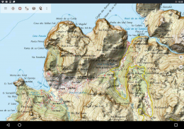
•西班牙Topo地图:MapaTopográficoNacional1:50.000&1:25.000(IGN MTN25和MTN50)

•IGN基本地图:BaseTopográficaNacional1:25.000(BTN25&BCN25)

•西班牙图像:高分辨率航拍图像。 Plan NacionaldeOrtofotografíaAérea(PNOA)

•加泰罗尼亚地形图:加泰罗尼亚的高分辨率地形图

•土地登记地图:CartografíaCatastral

•OpenStreetMaps:这些众包地图是其他地图图层的一个非常有用的补充。包含许多独特的功能。

•OpenCycleMaps:这些地图非常适合规划自行车旅行

•ESRI地形

•ESRI航空影像

•ESRI街道地图

•谷歌路线图(仅限在线访问)

•Google卫星图像(仅限在线访问)

•Google地形图(仅限在线访问)

•Bing路线图(仅限在线访问)

•Bing卫星图像(仅限在线访问)

•晚上的地球

•山体阴影叠加


户外导航的主要特点:


•创建和编辑航点

•GoTo-Waypoint-Navigation

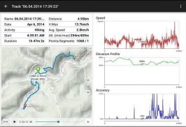
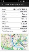
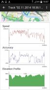
•跟踪记录(具有速度,高度和精度配置文件)

•Tripmaster带有里程表,平均速度,方位,高度等字段。

•GPX / KML / KMZ导出

•搜索(地名,POI,街道)

•Map View和Tripmaster中可自定义的数据字段(例如速度,距离,指南针......)

•分享航点,轨道或路线(通过电子邮件,Whatsapp,Dropbox,Facebook,..)

•以Lat / Lon,UTM或MGRS / USNG(军事网格/美国国家网格)显示坐标

•使用统计和高程配置文件记录和共享曲目

•旋转地图(向上和向北)

•通过长按地图获取海拔

•跟踪重播

• 还有很多 ...


可用的Pro功能:(通过In App Purchase提供的Pro功能)


•离线使用 - 无需细胞覆盖

•轻松+快速批量下载地图图块以供离线使用(不适用于Google和Bing地图)

•创建和编辑路线

•路线导航(点对点导航)

•GPX / KML / KMZ导入

•无限的航点和曲目

•添加其他Map Tile-Server

• 无广告


离线使用:

所有查看的地图图块都保存在缓存中。要缓存大区域,您需要购买Pro功能。


使用此导航应用程序进行户外活动,如远足,骑自行车,露营,登山,骑马,滑雪,划独木舟,狩猎,越野四驱车旅行或搜索和救援(SAR)。


使用WGS84基准以经度/纬度,UTM或MGRS / USNG格式添加自定义航路点。


以GPX或Google Earth KML / KMZ格式导入/导出/共享GPS-Waypoints / Tracks / Routes。


预加载没有小区服务的区域的免费地图数据(专业版功能!)。


对spainmaps@atlogis.com的评论和功能请求


请查看我们的其他户外导航应用:https://play.google.com/store/search?q = .atlogis


+++我们不会跟踪任何用户活动或收集任何用户数据! +++


Spain Topo Maps - 版本7.2.0

(12-01-2024)
其他版本
新特性• Improvements & Fixes

还没有评论或评分!要留下第一条评论或评分,请

-
1 Reviews
5
4
3
2
1
Info Trust Icon
保证非恶意应用此应用已通过病毒、恶意软件和其他恶意攻击的安全测试,不含任何威胁。

Spain Topo Maps - APK信息

APK版本: 7.2.0程序包: com.atlogis.spain
Android兼容性: 5.1+ (Lollipop)
开发商:ATLOGIS Geoinformatics GmbH & Co. KG隐私政策:http://www.atlogis.com/Atlogis_Privacy_Policy.pdf权限:21
名称: Spain Topo Maps大小: 15.5 MB下载次数: 704版本: 7.2.0发布日期: 2024-03-21 09:46:19最小屏幕: SMALL支持的CPU:
程序包ID: com.atlogis.spainSHA1签名: D8:C6:8E:17:4B:AE:BE:EC:B8:F7:8C:E9:6D:07:66:55:4D:D0:F8:5C开发商 (CN): Atlogis Geoinformatics oHG组织 (O): Atlogis Geoinformatics oHG本地 (L): G√ºtersloh国家/地区 (C): DE州/市 (ST): NRW

Spain Topo Maps的最新版本

7.2.0Trust Icon Versions
12/1/2024
704 下载次数15 MB 大小

其他版本

7.1.0Trust Icon Versions
25/10/2023
704 下载次数12.5 MB 大小
7.0.4Trust Icon Versions
19/8/2023
704 下载次数12.5 MB 大小
7.0.3Trust Icon Versions
17/7/2023
704 下载次数12.5 MB 大小
7.0.0Trust Icon Versions
21/3/2023
704 下载次数12.5 MB 大小
6.9.1Trust Icon Versions
20/1/2023
704 下载次数12.5 MB 大小
6.9.0Trust Icon Versions
14/1/2023
704 下载次数12.5 MB 大小
6.8.0Trust Icon Versions
11/7/2022
704 下载次数12 MB 大小
6.7.1Trust Icon Versions
6/12/2021
704 下载次数10.5 MB 大小
6.7.0Trust Icon Versions
20/11/2021
704 下载次数10.5 MB 大小

同类应用

您可能还会喜欢……